R.E.News future Tecnology-Komatsu and Sony hook up for drone brain
 18/09/24-FR-English-NL-footer
Komatsu et Sony s'associent pour créer un cerveau de drone
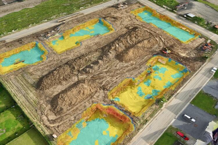
 Komatsu's Edge is a terrain mapping tool using AI to remove obstacles such as machinery and buildings from drone surveys
Une joint-venture japonaise a mis au point un nouvel outil de topographie qui combine drones et intelligence artificielle.
EarthBrain est une joint-venture de Komatsu, le fabricant japonais de machines de construction, avec NTT Communications, Sony Semiconductor et Nomura Research Institute, pour promouvoir la numérisation et l'avancement des processus de relevé par drone.
Avec sa dernière évolution Edge, Komatsu Smart Construction propose désormais un outil de cartographie du terrain utilisant l'IA pour supprimer les obstacles tels que les machines et les bâtiments des relevés par drone, réduisant ainsi le besoin de modifications manuelles et de rangement une fois les données capturées.
Komatsu affirme qu'Edge permet aux experts comme aux débutants d'effectuer des relevés par drone précis et de transformer les vols de drone en nuages de points.
Edge a été initialement dévoilé au salon Intermat à Paris en avril 2024 et dans plusieurs autres pays européens.
Bart Vingerhoets, directeur commercial senior chez Komatsu Smart Construction, a déclaré : « L'un des principaux avantages de notre solution Edge mise à jour est sa capacité à accélérer le traitement des données issues des relevés par drone pour créer un jumeau numérique entièrement précis. Lorsqu'elles sont connectées à la solution de tableau de bord Smart Construction, les cartes de terrain 3D disponibles permettent de gagner du temps sur le chantier et les données collectées, notamment le volume, le pourcentage d'avancement et l'emplacement sur le chantier, peuvent être collectées rapidement et efficacement. »
NJC.© Info KOMATSU
-----------------------------------------------------------------------------------------------------
 18/09/24-English
Komatsu and Sony hook up for drone brain
 Komatsu's Edge is a terrain mapping tool using AI to remove obstacles such as machinery and buildings from drone surveys
A Japanese joint venture has come up with a new surveying tool that combines drones and artificial intelligence.
EarthBrain is joint venture of Komatsu, the Japanese construction machinery manufacturer, with NTT Communications, Sony Semiconductor and Nomura Research Institute, to champion digitalisation and advancement in drone surveying processes.
With its latest Edge evolution, Komatsu Smart Construction now offers a terrain mapping tool using AI to remove obstacles such as machinery and buildings from drone surveys, reducing the need for manual amendments and tidying once the data has been captured.
Komatsu says that Edge enables both experts and beginners to perform accurate drone surveys and process drone flights into point clouds.
Edge was initially unveiled at the Intermat trade show in Paris in April 2024 and several other European countries.
Bart Vingerhoets, senior commercial manager at Komatsu Smart Construction, said: “A major benefit of our updated Edge solution is its ability to speed up data processing from drone surveys to create a fully accurate, digital twin. When connected with the Smart Construction dashboard solution, the 3D terrain maps available will save time spent on the jobsite and the data collected including volume, percentage of progress and location on site can be collected quickly and efficiently.”
NJC.© Info KOMATSU
---------------------------------------------------------------------------------------------------------------
 18/09/24-NL
Komatsu en Sony bundelen krachten voor dronebrein
 Image-Komatsu's Edge is a terrain mapping tool using AI to remove obstacles such as machinery and buildings from drone surveys
Een Japanse joint venture heeft een nieuwe landmeetkundige tool ontwikkeld die drones en kunstmatige intelligentie combineert.
EarthBrain is een joint venture van Komatsu, de Japanse fabrikant van bouwmachines, met NTT Communications, Sony Semiconductor en Nomura Research Institute, om digitalisering en vooruitgang in droneonderzoeksprocessen te bevorderen.
Met zijn nieuwste Edge-evolutie biedt Komatsu Smart Construction nu een terreinkaarttool die AI gebruikt om obstakels zoals machines en gebouwen uit droneonderzoeken te verwijderen, waardoor de noodzaak voor handmatige wijzigingen en opruiming nadat de gegevens zijn vastgelegd, wordt verminderd.
Komatsu zegt dat Edge zowel experts als beginners in staat stelt om nauwkeurige droneonderzoeken uit te voeren en dronevluchten te verwerken tot puntenwolken.
Edge werd voor het eerst onthuld op de Intermat-beurs in Parijs in april 2024 en verschillende andere Europese landen.
Bart Vingerhoets, senior commercieel manager bij Komatsu Smart Construction, zei: "Een groot voordeel van onze bijgewerkte Edge-oplossing is het vermogen om de gegevensverwerking van drone-onderzoeken te versnellen om een volledig nauwkeurige, digitale tweeling te creëren. Wanneer verbonden met de Smart Construction-dashboardoplossing, besparen de beschikbare 3D-terreinkaarten tijd die op de bouwplaats wordt doorgebracht en kunnen de verzamelde gegevens, waaronder volume, percentage voortgang en locatie op de bouwplaats, snel en efficiënt worden verzameld."
NJC.© Info KOMATSU
--------------------------------------------------------------------------------------------------------------------
Date de dernière mise à jour : 17/09/2024


